- Projects
- Insights
-
Careers

Careers
Ranked a Top Workplace and ENR Top 500 Design Firm, Burns offers opportunities to inspire, create and deliver transformational projects that last generations.
- News + Events
-
About

About
Burns inspires, creates and delivers specialized-engineering solutions for mission-critical facilities.
- Offices
-
What We Do
Discipline
Expertise
Industry-Specific - Projects
- Insights
- Careers
- News + Events
- About
- Offices
"*" indicates required fields
Shining a Light on LIDAR: Practical Applications for the Aviation Industry
What if airport facility managers could implement a technology that could detect, classify, and track people and vehicles without privacy concerns? Those things and more are possible with LIDAR. LIDAR has been used in the automotive industry for years, but the aviation industry is only now realizing the benefits of the technology in the built environment.
What is LIDAR?
LIDAR, which stands for Light Detection and Ranging, uses pulses of invisible infrared laser light from sensors to detect, classify and track objects with sub-centimeter accuracy. LIDAR sensors generally look like dome video surveillance cameras. Like cameras, the sensors have different fields of view, which have tradeoffs for distances at which the sensors can detect objects, and for the precision of determining the object distance from the sensor. After the sensors gather data of millions of points per second, with data rates in the 20Mbps to 300Mbps range, the software turns that data into 3D point clouds of the detected objects.
The detected objects visualized by the 3D point clouds can then be classified by the software as people, vehicles, or other objects. Those objects can also be defined by their speed, size, direction of movement or other attributes. After the objects are classified, the software can then provide information for the more efficient operation of a facility.
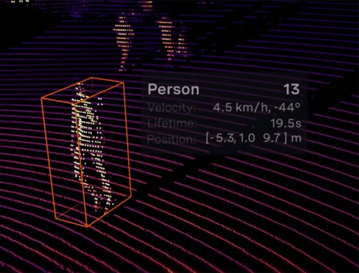
Example of what a LIDAR capture of a person looks like | Image courtesy of Ouster
LIDAR can be integrated with video systems to provide a more effective security system. It can detect and classify objects at great distances, and depending on the risk assigned to that object, the target can be tracked optically with the cameras with an automatic camera handover. This is especially useful for monitoring large spaces like airfields.
How Can it be Implemented on an Aviation Facilities Project?
There are many ways to implement LIDAR in an aviation facilities project. In some cases, it can significantly accelerate building systems design processes, particularly when planning airport renovations without reliable as-built drawings for piping, conduits, or ductwork above ceilings. One practical solution is to deploy LIDAR units in ceiling spaces to capture point cloud data, which can then be exported into BIM software. Pairing LIDAR with optical imaging enhances this approach by allowing teams to read labels on piping and conduits, providing valuable insight into system functions.
Taking this a step further, both above- and below-ceiling environments can be mapped using LIDAR and optical tools to create a comprehensive virtual model of the facility. This model could evolve into a digital twin that supports testing, monitoring, and ongoing maintenance. Beyond design applications, LIDAR also offers operational benefits in airport environments, including tracking occupancy, monitoring line crossings, measuring baggage size, identifying congestion, evaluating resource usage detecting loitering, and recognizing mobility assistance needs. It can also support monitoring of apron operations.
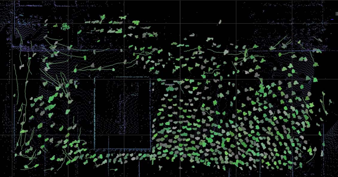
Example of an overhead, or birds eye LIDAR capture in an open space. | Image courtesy of Ouster
To maximize value, it is important to clearly define the intended application of LIDAR and determine whether it is the best fit. LIDAR excels at accurately measuring position and velocity, operates reliably in varying lighting conditions, and presents minimal privacy concerns, as it does not capture personally identifiable characteristics such as race, gender, or facial features. However, optical camera systems with video analytics may be better suited for applications requiring detailed visual context and can sometimes offer a more cost-effective solution. Ultimately, selecting the right technology depends on the project’s goals, and our aviation team can help guide that decision and implementation process.
Our Experience
Burns has implemented LIDAR at numerous types of airport facilities and situations. Our projects have included things like queue management at security checkpoints at multiple airports to interactive elements at a large AV installation at an international airport. We are currently in talks with a client about using LIDAR to detect, classify, and track vehicles and people at drop-off points. The analytics would include number and types of vehicles, speed, traffic flow, dwell time and number of people in and out of vehicles.
There are various systems available to help aviation facilities run more efficiently or help them do their jobs more efficiently, but LIDAR represents a new frontier in building systems design work. The Burns aviation team is poised to provide solutions to help facilities managers use the technology in the most advantageous ways possible.